Offa's Dyke
George Borrow, in his classic Wild Wales, notes that once ‘it
was customary for the English to cut off the ears of every Welshman who was
found to the east of the Dyke, and for the Welsh to hang every Englishman whom
they found to the west of it’. Certainly, Offa’s Dyke has provided
a potent symbol of Welsh-English antipathy ever since it was created in the
eighth century AD, as a demarcation line by King Offa of Mercia ruler of central
England.
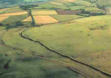 Winding
across the upland landscape of west Shropshire like a huge snake is Offa's Dyke.
Constructed during the late eighth century AD on the orders of King Offa (757-796),
the monument is a testament to the power and strength of the Mercian Kingdom
and of the ruler whose name it bears. The Dyke is the longest archaeological
monument in Britain: Shropshire is fortunate in having within its borders some
of the finest surviving sections. The Dyke can be seen as a continuous linear
earthwork still standing up to two metres high, flanked on the west by a wide
ditch. Throughout its entire length the Dyke is sited wherever possible to make
use of west-facing slopes and vantage points looking out towards Wales. Winding
across the upland landscape of west Shropshire like a huge snake is Offa's Dyke.
Constructed during the late eighth century AD on the orders of King Offa (757-796),
the monument is a testament to the power and strength of the Mercian Kingdom
and of the ruler whose name it bears. The Dyke is the longest archaeological
monument in Britain: Shropshire is fortunate in having within its borders some
of the finest surviving sections. The Dyke can be seen as a continuous linear
earthwork still standing up to two metres high, flanked on the west by a wide
ditch. Throughout its entire length the Dyke is sited wherever possible to make
use of west-facing slopes and vantage points looking out towards Wales.
Therein lies the origin of the Dyke as a boundry between the Kingdom of Mercia
and the Welsh Kingdoms to the west; the Dyke probably served both to regulate
access to and from Wales and at the same time to check cross-border raids from
the west.
The frontier defined by this remarkable earthwork extended from the Severn Estuary,
near Chepstow in the south, to the North Wales coast at Prestatyn. The sheer
scale of this huge undertaking shows that this was intended as a frontier for
all time. It is fitting that even today lengths of the Dyke form a national
boundry between England and Wales.
Today’s England-Wales border crosses the Dyke many times, although
the basic boundary has changed little since Offa’s day. The glorious 177-mile
long distance footpath, opened in 1971, and is one of the most rewarding walks
in Britain. |